|
TERMS OF USE:
This free image can only be used for non-commercial, personal
website use only. THIS IMAGE CANNOT BE
used in galleries, downloaded to your computer, posted on sites for
others to use, manipulated, downsized, or upsized. If you are confused about the
terms of use or have any questions then contact us before using the image.
Free Picture: Iturralde Structure, Bolivia
|
Description
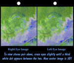
An 8-kilometer (5-mile) wide crater of possible impact origin is shown in this stereoscopic view of an isolated part of the Bolivian Amazon. The view is derived from an Advanced Spaceborne Thermal Emission and Reflection Radiometer (ASTER) satellite image and a Shuttle Radar Topography Mission (SRTM) elevation model. The circular feature covering much of the image, known as the Iturralde Structure, is possibly the Earth's most recent "big" impact event recording collision with a meteor or comet that might have occurred between 11,000 and 30,000 years ago. Although the structure was identified on satellite photographs in the mid-1980s, its location is so remote that it has only been visited by scientific investigators twice, most recently by a team from NASA's Goddard Space Flight Center in September 2002. Lying in an area of very low relief, the landform is a quasi-circular closed depression only about 20 meters (66 feet) in depth, with sharply defined sub-angular "rim" materials. It resembles a "cookie cutter" in that its appearance "cuts" the heavily vegetated soft-sediments and pampas of this part of Bolivia. The SRTM data have provided investigators with the first topographic map of the site and will allow studies of its three-dimensional structure crucial to determining whether it actually is of impact origin. This stereoscopic image was generated by first draping the ASTER satellite image over the Shuttle Radar Topography Mission digital elevation model. Two differing perspectives were then calculated, one for each eye. They can be seen in 3-D by viewing the left image with the right eye and the right image with the left eye (cross-eyed viewing) or by downloading and printing the image pair and viewing them with a stereoscope. When stereoscopically merged, the result is a vertically exaggerated view of Earth's surface in its full three dimensions. Thick vegetation in part defines the surface that the SRTM radar sees as it maps the terrain. Much of the local "topography" in this area is a measure of tree height (typically up to 13 meters, or 40 feet). This effect is easily seen here, where the ground surface relief is very low. Interpretative separation of the ground surface and vegetative features can typically be made by recognition of their characteristic patterns. However, by integrating the ASTER data into the visualization, spectral colors help the recognition of terrain features (green vegetation and blue water).
Keywords
3d, bolivia, bolivian amazon, geography, iturralde structure bolivia, jpl, nasa, iturralde structure, free photography, free photo, free photos, free picture, free pictures, free image, free images
|
Similar Free geography Pictures
|
|
|
|


