|
TERMS OF USE:
This free image can only be used for non-commercial, personal
website use only. THIS IMAGE CANNOT BE
used in galleries, downloaded to your computer, posted on sites for
others to use, manipulated, downsized, or upsized. If you are confused about the
terms of use or have any questions then contact us before using the image.
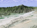
Free Picture: Palm Springs
|
Description
The city of Palm Springs nestles at the base of Mount San Jacinto in this computer-generated perspective viewed from the east. The many golf courses in the area show up as irregular green areas while the two prominent lines passing through the middle of the image are Interstate 10 and the adjacent railroad tracks. The San Andreas Fault passes through the middle of the sandy Indio Hills in the foreground. This 3-D perspective view was generated using topographic data from the Shuttle Radar Topography Mission (SRTM) and an enhanced color Landsat 5satellite image. Topographic expression is exaggerated two times.
Keywords
ca, cali, calif, california, fault, faults, geography, golf courses, indio hills, interstate 10, jpl, mount san jacinto, nasa, palm springs ca, palm springs cali, palm springs calif, palm springs california, san andreas fault, palm springs, free photography, free photo, free photos, free picture, free pictures, free image, free images
|
Similar Free geography Pictures
|
|
|
|


