|
TERMS OF USE:
This free image can only be used for non-commercial, personal
website use only. THIS IMAGE CANNOT BE
used in galleries, downloaded to your computer, posted on sites for
others to use, manipulated, downsized, or upsized. If you are confused about the
terms of use or have any questions then contact us before using the image.
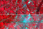
Free Picture: La Plata, Maryland
|
Description
On Sunday, April 28, a category F5 tornado cut an East-West path through La Plata, Maryland, killing 5 and injuring more than 100. These two images acquired by NASA's Terra satellite Advanced Spaceborne Thermal Emission and Reflection Radiometer (ASTER) show a 6-by-17.8-kilometer (3.7-by-11.1-mile) area centered on the town. The top image was acquired on May 12, 2001, and the bottom on May 3, 2002. The bands used for the image portray vegetation in red, and bare fields and urban areas in blue-green. The dark turquoise swath cutting across the 2002 image is the track of the tornado, where the vegetation was ripped up and removed.
Keywords
category f5 tornado, earth science, f5 tornado, geography, jpl, la plata maryland, maryland, nasa, tornado, tornadoes, la plata, free photography, free photo, free photos, free picture, free pictures, free image, free images
|
Similar Free geography Pictures
|
|
|
|


