|
TERMS OF USE:
This free image can only be used for non-commercial, personal
website use only. THIS IMAGE CANNOT BE
used in galleries, downloaded to your computer, posted on sites for
others to use, manipulated, downsized, or upsized. If you are confused about the
terms of use or have any questions then contact us before using the image.
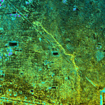
Free Picture: Old Khmer Road, Cambodia
|
Description
This image shows the Old Khmer Road (Inrdratataka-Bakheng causeway) in Cambodia extending from the 9th Century A.D. capitol city of Hariharalaya in the lower right portion of the image to the later 10th Century AD capital of Yasodharapura. This was located in the vicinity of Phnom Bakheng (not shown in image). The Old Road is believed to be more than 1000 years old. Its precise role and destination within the "new" city at Angkor is still being studied by archeologists. But wherever it ended, it not only offered an immense processional way for the King to move between old and new capitols, it also linked the two areas, widening the territorial base of the Khmer King. Finally, in the past and today, the Old Road managed the waters of the floodplain. It acted as a long barrage or dam for not only the natural streams of the area but also for the changes brought to the local hydrology by Khmer population growth.
Keywords
cambodia, causeway, geography, hariharalaya, inrdratataka-bakheng causeway, jpl, nasa, old khmer road cambodia, radar image, radar images, old khmer road, free photography, free photo, free photos, free picture, free pictures, free image, free images
|
Similar Free geography Pictures
|
|
|
|


