|
TERMS OF USE:
This free image can only be used for non-commercial, personal
website use only. THIS IMAGE CANNOT BE
used in galleries, downloaded to your computer, posted on sites for
others to use, manipulated, downsized, or upsized. If you are confused about the
terms of use or have any questions then contact us before using the image.
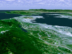
Free Picture: San Francisco Bay Area
|
Description
The defining landmarks of San Francisco, its bay and the San Andreas Fault are clearly seen in this computer-generated perspective viewed from the south. Running from the bottom of the scene diagonally up to the left, the trough of the San Andreas Fault is occupied by Crystal Springs Reservoir and San Andreas Lake. Interstate 280 winds along the side of the fault. San Francisco International Airport is the angular feature projecting into the bay just below San Bruno Mountain, the elongated ridge cutting across the peninsula. The hills of San Francisco can be seen beyond San Bruno Mountain and beyond the city, the Golden Gate. This 3-D perspective view was generated using topographic data from the Shuttle Radar Topography Mission (SRTM) and an enhanced color Landsat 5satellite image. Topographic expression is exaggerated two times.
Keywords
bay, bay area, ca, cali, calif, california, crystal springs reservoir, geography, golden gate, interstate 280, jpl, nasa, peninsula, san andreas fault, san andreas lake, san bruno mountain, san fran, san fran bay area, san francisco, san francisco international airport, sf, sf bay area, san francisco bay area, free photography, free photo, free photos, free picture, free pictures, free image, free images
|
Similar Free geography Pictures
|
|
|
|


