|
TERMS OF USE:
This free image can only be used for non-commercial, personal
website use only. THIS IMAGE CANNOT BE
used in galleries, downloaded to your computer, posted on sites for
others to use, manipulated, downsized, or upsized. If you are confused about the
terms of use or have any questions then contact us before using the image.
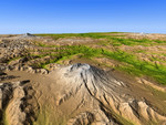
Free Picture: Mount Saint Helens, Washington
|
Description
Mount Saint Helens is a prime example of how Earth's topographic form can greatly change even within our lifetimes. The mountain is one of several prominent volcanoes of the Cascade Range that stretches from British Columbia, Canada, southward through Washington, Oregon, and into northern California. Mount Adams (left background) and Mount Hood (right background) are also seen in this view, which was created entirely from elevation data produced by the Shuttle Radar Topography Mission. Prior to 1980, Mount Saint Helens had a shape roughly similar to other Cascade peaks, a tall, bold, irregular conic form that rose to 2950 meters (9677 feet). However, the explosive eruption of May 18, 1980, caused the upper 400 meters (1300 feet) of the mountain to collapse, slide, and spread northward, covering much of the adjacent terrain (lower left), leaving a crater atop the greatly shortened mountain. Subsequent eruptions built a volcanic dome within the crater, and the high rainfall of this area lead to substantial erosion of the poorly consolidated landslide material. Eruptions at Mount Saint Helens subsided in 1986, but renewed volcanic activity here and at other Cascade volcanoes is inevitable. Predicting such eruptions still presents challenges, but migration of magma within these volcanoes often produces distinctive seismic activity and minor but measurable topographic changes that can give warning of a potential eruption.
Keywords
earth science, geography, jpl, mount adams, mount hood, mount st helens, mountain, mt adams, mt hood, mt saint helens, mt st helens, nasa, saint helens, st helens, volcano, volcanoes, washington, mount saint helens, free photography, free photo, free photos, free picture, free pictures, free image, free images
|
Similar Free geography Pictures
|
|
|
|


