|
TERMS OF USE:
This free image can only be used for non-commercial, personal
website use only. THIS IMAGE CANNOT BE
used in galleries, downloaded to your computer, posted on sites for
others to use, manipulated, downsized, or upsized. If you are confused about the
terms of use or have any questions then contact us before using the image.
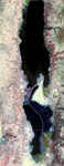
Free Picture: The Dead Sea
|
Description
The Dead Sea is the lowest point on Earth at 418 meters below sea level, and also one of the saltiest bodies of water on Earth with a salinity of about 300 parts-per-thousand (nine times greater than ocean salinity). It is located on the border between Jordan and Israel, and is fed by the Jordan River. The Dead Sea is located in the Dead Sea Rift, formed as a result of the Arabian tectonic plate moving northward away from the African Plate. The mineral content of the Dead Sea is significantly different from that of ocean water, consisting of approximately 53% magnesium chloride, 37% potassium chloride and 8% sodium chloride. In the early part of the 20th century, the Dead Sea began to attract interest from chemists who deduced that the Sea was a natural deposit of potash and bromine. From the Dead Sea brine, Israel and Jordan produce 3.8 million tons potash, 200,000 tons elemental bromine, 45,000 tons caustic soda, 25, 000 tons magnesium metal, and sodium chloride. Both countries use extensive salt evaporation pans that have essentially diked the entire southern end of the Dead Sea.
Keywords
dead sea, dead sea from space, dead sea rift, from space, geography, israel, jordan, jordan river, jpl, nasa, the dead sea from space, view from space, the dead sea, free photography, free photo, free photos, free picture, free pictures, free image, free images
|
Similar Free geography Pictures
|
|
|
|


