|
TERMS OF USE:
This free image can only be used for non-commercial, personal
website use only. THIS IMAGE CANNOT BE
used in galleries, downloaded to your computer, posted on sites for
others to use, manipulated, downsized, or upsized. If you are confused about the
terms of use or have any questions then contact us before using the image.
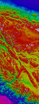
Free Picture: Western Tibet
|
Description
The 5000 meter (16,000 feet) high Tibetan Plateau has been formed by the collision of the Indian subcontinent with central Asia. The topography rises from the Indus-Ganges plains across the Himalayas and into the lower relief central part of the plateau. The north edge of the plateau is the Altyn Tagh and Kun Lun mountain range. North of Tibet is the Takla Makan desert. Two major faults in western Tibet stand out in the topography and satellite imagery. The Karakoram Fault is the straight line running from top left to lower right across this image, through the Karakoram mountains and southern Tibet. The Altyn Tagh Fault is the slightly curved line running along the northern edge of the plateau from top left to top right. Geologist s and geophysicists have long argued about how fast these two faults in western Tibet are moving. In one model, the Tibetan plateau is like a watermelon seed sliding out to the east along these two faults. In another model, Tibet is deforming internally without sliding rapidly sideways. Scientists at the Centre for Observation and Modelling of Earthquakes and Tectonics and at NASA's Jet Propulsion Lab have used interferometric analysis of radar data from the European Remote Sensing satellites and topographic data from the Shuttle Radar Topography Mission to study the faults in western Tibet. The interferometric analysis was performed with software developed at JPL. The results show that the faults in western Tibet, especially the Karakoram Fault, cannot be moving rapidly. This rules out the watermelon seed "extrusion" model, at least for western Tibet.
Keywords
altyn tagh, altyn tagh and kun lun mountain range, altyn tagh fault, earth science, fault, faults, geography, himalayas, indus ganges plains, jpl, karakoram fault, karakoram mountains, kun lun, nasa, takla makan desert, tibet, tibetan plateau, topography, western tibet, free photography, free photo, free photos, free picture, free pictures, free image, free images
|
Similar Free geography Pictures
|
|
|
|


