|
TERMS OF USE:
This free image can only be used for non-commercial, personal
website use only. THIS IMAGE CANNOT BE
used in galleries, downloaded to your computer, posted on sites for
others to use, manipulated, downsized, or upsized. If you are confused about the
terms of use or have any questions then contact us before using the image.
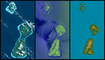
Free Picture: Bora Bora, Tahaa, and Raiatea, French Polynesia
|
Description
Bora Bora, Tahaa, and Raiatea (top to bottom) are Polynesian Islands about 220 kilometers (135 miles) west-northwest of Tahiti in the South Pacific. Each of the islands is surrounded by a coral reef and its associated islets ("motus") that enclose a lagoon. Actually, as seen here, Tahaa and Raiatea are close enough together to share a common lagoon and reef. These islands are volcanic in origin and were built up from the sea floor by lava extrusions millions of years ago. None is now active, and all are deeply eroded. This display compares three differing "views from space" of these islands. On the left, an image from the Landsat 7 satellite shows the islands as they might have appeared to an astronaut in orbit in 1999 (but a little sharper and with atmospheric haze suppressed). In the middle is an image created from data gathered by the third-generation Shuttle Imaging Radar (SIR-C), flown in 1994. On the right is a graphic illustrating elevation data gathered by the Shuttle Radar Topography Mission (SRTM) in 2000. Each of these images shows very different information as compared to the other two. Landsat sees clouds, which are almost always above these islands, blocking the view of the terrain. It also readily sees through shallow water down to the reefs. SIR-C sees the waves and other effects of winds upon the ocean surface. It does not look through water to see the reefs, but it clearly separates land and water. It also provides a bolder (but distorted) view of the islands' topographic patterns. With the ability of radar to see through clouds and provision of its own illumination, the SIR-C view is not limited by clouds nor their shadows.
Keywords
earth science, french polynesia, geography, island, islands, jpl, nasa, raiatea, tahaa, bora bora, free photography, free photo, free photos, free picture, free pictures, free image, free images
|
Similar Free geography Pictures
|
|
|
|


