|
TERMS OF USE:
This free image can only be used for non-commercial, personal
website use only. THIS IMAGE CANNOT BE
used in galleries, downloaded to your computer, posted on sites for
others to use, manipulated, downsized, or upsized. If you are confused about the
terms of use or have any questions then contact us before using the image.
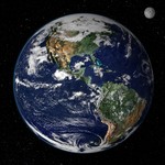
Free Picture: Earth from Space

|
Description
This true-color image shows North and South America as they would appear from space 35,000 km (22,000 miles) above the Earth. The image is a combination of data from two satellites. The Moderate Resolution Imaging Spectroradiometer (MODIS) instrument aboard NASA’s Terra satellite collected the land surface data over 16 days, while NOAA’s Geostationary Operational Environmental Satellite (GOES) produced a snapshot of the Earth’s clouds. Image created by Reto Stöckli, Nazmi El Saleous, and Marit Jentoft-Nilsen, NASA GSFC.
Keywords
earth, from space, geography, nasa, north america, planet earth, south america, the earth, view from space, earth from space, free photography, free photo, free photos, free picture, free pictures, free image, free images
|
Similar Free earth Pictures
|
|
|
|