|
TERMS OF USE:
This free image can only be used for non-commercial, personal
website use only. THIS IMAGE CANNOT BE
used in galleries, downloaded to your computer, posted on sites for
others to use, manipulated, downsized, or upsized. If you are confused about the
terms of use or have any questions then contact us before using the image.
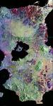
Free Picture: Russia's Lena Delta and Olenek
|
Description
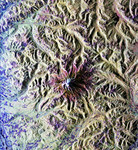
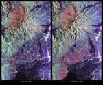
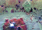
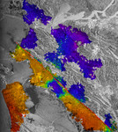
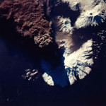
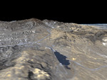
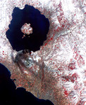
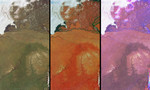
These views of the Russian Arctic were acquired by NASA's Multi-angle Imaging SpectroRadiometer (MISR) instrument on July 11, 2004, when the brief arctic summer had transformed the frozen tundra and the thousands of lakes, channels, and rivers of the Lena Delta into a fertile wetland, and when the usual blanket of thick snow had melted from the vast plains and taiga forests. This set of three images cover an area in the northern part of the Eastern Siberian Sakha Republic. The Olenek River wends northeast from the bottom of the images to the upper left, and the top portions of the images are dominated by the delta into which the mighty Lena River empties when it reaches the Laptev Sea. At left is a natural color image from MISR's nadir (vertical-viewing) camera, in which the rivers appear murky due to the presence of sediment, and photosynthetically-active vegetation appears green. The center image is also from MISR's nadir camera, but is a false color view in which the predominant red color is due to the brightness of vegetation at near-infrared wavelengths. The most photosynthetically active parts of this area are the Lena Delta, in the lower half of the image, and throughout the great stretch of land that curves across the Olenek River and extends northeast beyond the relatively barren ranges of the Volyoi mountains (the pale tan-colored area to the right of image center). The right-hand image is a multi-angle false-color view made from the red band data of the 60º backward, nadir, and 60º forward cameras, displayed as red, green and blue, respectively. Water appears blue in this image because sun glitter makes smooth, wet surfaces look brighter at the forward camera's view angle. Much of the landscape and many low clouds appear purple since these surfaces are both forward and backward scattering, and clouds that are further from the surface appear in a different spot for each view angle, creating a rainbow-like appearance. However, the vegetated region that is d
Keywords
earth science, eastern siberian sakha republic, jpl, laptev sea, lena river, nasa, olenek, olenek river, russia, russian arctic, volyoi mountains, lena delta, free photography, free photo, free photos, free picture, free pictures, free image, free images
|
Similar Free earth science Pictures
|
|
|
|