|
TERMS OF USE:
This free image can only be used for non-commercial, personal
website use only. THIS IMAGE CANNOT BE
used in galleries, downloaded to your computer, posted on sites for
others to use, manipulated, downsized, or upsized. If you are confused about the
terms of use or have any questions then contact us before using the image.
Free Picture: Kliuchevskoi, Russia
|
Description
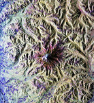
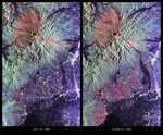
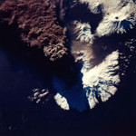
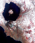
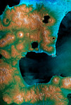
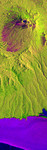
This is an X-band seasonal image of the Maly Semlyachik volcano, which is part of the Karymsky volcano group on Kamchatka peninsula, Russia. The image is centered at 54.2 degrees north latitude and 159.6 degrees east longitude. This image was acquired by the Spaceborne Imaging Radar-C and X-band Synthetic Aperture Radar (SIR-C/X-SAR) aboard the space shuttle Endeavour on April 9, 1994, during the first flight of the radar system, and on September 30, 1994, during the second flight. The image channels have been assigned the following colors: red corresponds to data acquired on April 9; green corresponds to data acquired on September 30; and blue corresponds to the ratio between data from April 9 and September 30, 1994. Kamchatka is twice as large as England, Scotland and Wales combined and is home to approximately 470,000 residents. The region is characterized by a chain of volcanoes stretching 800 kilometers (500 miles) across the countryside. Many of the volcanoes, including the active Maly Semlyachik volcano in this image, have erupted during this century. But the most active period in creating the three characteristic craters of this volcano goes back 20,000, 12,000 and 2,000 years ago. The highest summit of the oldest crater reaches about 1,560 meters (1,650 feet). The radar images reveal the geological structures of craters and lava flows in order to improve scientists' knowledge of these sometimes vigorously active volcanoes. This seasonal composite also highlights the ecological differences that have occurred between April and October 1994. In April the whole area was snow-covered and, at the coast, an ice sheet extended approximately 5 kilometers (3 miles) into the sea. The area shown surrounding the volcano is covered by low vegetation much like scrub. Kamchatka also has extensive forests, which belong to the northern frontier of Taiga, the boreal forest ecosystem. This region plays an important role in the world's carbon cycle. Trees require 60 years to ma
Keywords
earth science, jpl, kamchatka peninsula, karymsky volcano, kliuchevskoi, kliuchevskoi russia, maly semlyachik volcano, russia, volcano, volcanoes, nasa, free photography, free photo, free photos, free picture, free pictures, free image, free images
|
Similar Free volcano Pictures
|
|
|
|