|
TERMS OF USE:
This free image can only be used for non-commercial, personal
website use only. THIS IMAGE CANNOT BE
used in galleries, downloaded to your computer, posted on sites for
others to use, manipulated, downsized, or upsized. If you are confused about the
terms of use or have any questions then contact us before using the image.
Free Picture: Southern Florida
|
Description
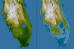
The very low topography of southern Florida is evident in this color-coded shaded relief map generated with data from the Shuttle Radar Topography Mission. The image on the left is a standard view, with the green colors indicating low elevations, rising through yellow and tan, to white at the highest elevations. In this exaggerated view even those highest elevations are only about 60 meters (197 feet) above sea level. For the view on the right, elevations below 5 meters (16 feet) above sea level have been colored dark blue, and lighter blue indicates elevations below 10 meters (33 feet). This is a dramatic demonstration of how Florida's low topography, especially along the coastline, make it especially vulnerable to flooding associated with storm surges. Planners can use data like these to predict which areas are in the most danger and help develop mitigation plans in the event of particular flood events.
Keywords
earth science, fl, florida, geography, jpl, nasa, southern florida, free photography, free photo, free photos, free picture, free pictures, free image, free images
|
Similar Free geography Pictures
|
|
|
|


