|
TERMS OF USE:
This free image can only be used for non-commercial, personal
website use only. THIS IMAGE CANNOT BE
used in galleries, downloaded to your computer, posted on sites for
others to use, manipulated, downsized, or upsized. If you are confused about the
terms of use or have any questions then contact us before using the image.
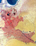
Free Picture: Western Uzbekistan and Northeastern Turkmenistan
|
Description
This false-color image was acquired by the Multi-angle Imaging SpectroRadiometer (MISR) in late June, 2002, and represents an area of about 292 kilometers x 370 kilometers. Data from the near-infrared, red and blue spectral bands of MISR's downward-viewing (nadir) camera are displayed as red, green and blue, respectively, causing highly vegetated areas to appear red.
Keywords
geography, jpl, nasa, northeastern turkmenistan, turkmenistan, uzbekistan, western uzbekistan, western uzbekistan and northeastern turkmenistan, free photography, free photo, free photos, free picture, free pictures, free image, free images
|
Similar Free geography Pictures
|
|
|
|


