|
TERMS OF USE:
This free image can only be used for non-commercial, personal
website use only. THIS IMAGE CANNOT BE
used in galleries, downloaded to your computer, posted on sites for
others to use, manipulated, downsized, or upsized. If you are confused about the
terms of use or have any questions then contact us before using the image.
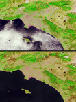
Free Picture: Burn Scars Across Southern California
|
Description
Brush fires consumed nearly 750,000 acres across Southern California between October 21 and November 18, 2003. Burn scars and vegetation changes wrought by the fires are illustrated in these false-color images captured on October 17 (top) and November 18 (bottom) by the Multi-angle Imaging SpectroRadiometer (MISR). The images were created by displaying red, near-infrared and green spectral band data from MISR's nadir(downward-looking) camera as red, green and blue, respectively. Living vegetation appears in shades of green and urban areas appear pale grey and pink. Recently burnt areas can be identified by their dramatic changes from vivid green to brown hues several weeks later. The locations of the largest fires are indicated by an annotated version of the November 18 image.
Keywords
brush fire, brush fires, burn scars, california, earth science, fire, fires, geography, jpl, nasa, southern california, burn scars across southern california, free photography, free photo, free photos, free picture, free pictures, free image, free images
|
Similar Free geography Pictures
|
|
|
|


