|
TERMS OF USE:
This free image can only be used for non-commercial, personal
website use only. THIS IMAGE CANNOT BE
used in galleries, downloaded to your computer, posted on sites for
others to use, manipulated, downsized, or upsized. If you are confused about the
terms of use or have any questions then contact us before using the image.
Free Picture: Salt Playas of the Bolivian Altiplano
|
Description
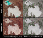
In the high plateau of southwestern Bolivia, two large salt deserts, or playas, are located between the eastern and western Andes. The Salar de Uyuni is the largest and highest playa in the world, encompassing an area of more than 9000 square kilometers and situated more than 3600 meters above sea level. It is separated by a range of hills from its smaller neighbor to the north, the Salar de Coipasa. During the Pleistocene the climate of the region was wetter and the entire area was covered by a massive lake. As the waters slowly dried, abundant dissolved minerals were left behind to form the playas. The salt pans are now excellent indicators of rainfall fluctuations within the region and are also important sites for the study of paleoclimatology. These two image pairs from the Multi-angle Imaging SpectroRadiometer (MISR)depict the playas on January 16, 2002 and January 3, 2003. At this time of year the wet season has already begun, and the Salar de Coipaso is usually at least partially flooded. Data from these two dates were processed identically to preserve relative variations in brightness between them. Varying degrees of surface moisture around the two playas are illustrated by the different display techniques of the right and left-hand panels. At left are two false-color views acquired by MISR's nadir camera. Data from the near-infrared, green and blue bands are displayed as red, green and blue. This spectral display causes bright, wet surfaces to appear blue-green because water selectively absorbs longer wavelengths such as near-infrared. Significantly more standing water is present in the Salar de Coipaso in 2002 than in 2003. However, a stronger signal at the near-infrared band on the 2003 date, which causes the overall hue in the 2003 image to be redder than 2002, suggests an increase in photosynthetic activity (plant growth) at the 2003 date compared with one year earlier. The right-hand panels were created using only red band data, and are multi-angle com
Keywords
bolivia, bolivian altiplano, desert, deserts, earth science, geography, jpl, nasa, playas, salar de coipasa, salar de coipaso, salar de uyuni, salt pans, salt playas, salt playas of the bolivian altiplano, free photography, free photo, free photos, free picture, free pictures, free image, free images
|
Similar Free geography Pictures
|
|
|
|


