|
TERMS OF USE:
This free image can only be used for non-commercial, personal
website use only. THIS IMAGE CANNOT BE
used in galleries, downloaded to your computer, posted on sites for
others to use, manipulated, downsized, or upsized. If you are confused about the
terms of use or have any questions then contact us before using the image.
Free Picture: Guiana Highlands
|
Description
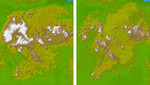
These two images show exactly the same area in South America, the Guiana Highlands straddling the borders of Venezuela, Guyana and Brazil. The image on the left was created using the best global topographic data set previously available, the U.S. Geological Survey's GTOPO30. In contrast, the image on the right was generated with a new data set recently released by the Shuttle Radar Topography Mission (SRTM) called SRTM30, which represents a significant improvement in our knowledge of the topography of much of the world. GTOPO30, with a resolution of about 928 meters (1496 feet), was developed over a three-year period and published in 1996, and since then has been the primary source of digital elevation data for scientists and analysts involved in global studies. However, since it was compiled from a number of different map sources with varying attributes, the data for some parts of the globe were inconsistent or of low quality. The SRTM data, on the other hand, were collected within a ten-day period using the same instrument in a uniform fashion, and were processed into elevation data using consistent processing techniques. Thus SRTM30 provides a new resource of uniform quality for all parts of the Earth, and since the data, which have an intrinsic resolution of about 30 meters, were averaged and resampled to match the GTOPO30 sample spacing and format, and can be used by the same computer software without modification. The Guiana Highlands are part of the Guyana Shield, which lies in northeast South America and represent one of the oldest land surfaces in the world. Chemical weathering over many millions of years has created a landscape of flat-topped table mountains with dramatic, steep cliffs with a large number of spectacular waterfalls. For example Angel Falls, at 979 meters the highest waterfall in the world, plunges from Auyan Tebuy, part of a mesa of the type that may have been the inspiration for Arthur Conan Doyle's 1912 best-seller "The Lost World."
Keywords
brazil, earth science, geography, guiana, guyana, highlands, jpl, nasa, south america, venezuela, guiana highlands, free photography, free photo, free photos, free picture, free pictures, free image, free images
|
Similar Free geography Pictures
|
|
|
|


