|
TERMS OF USE:
This free image can only be used for non-commercial, personal
website use only. THIS IMAGE CANNOT BE
used in galleries, downloaded to your computer, posted on sites for
others to use, manipulated, downsized, or upsized. If you are confused about the
terms of use or have any questions then contact us before using the image.
Free Picture: Bali
|
Description
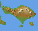
The volcanic nature of the island of Bali is evident in this shaded relief image generated with data from the Shuttle Radar Topography Mission (SRTM). Bali, along with several smaller islands, make up one of the 27 Provinces of Indonesia. It lies over a major subduction zone where the Indo-Australian tectonic plate collides with the Sunda plate, creating one of the most volcanically active regions on the planet. The most significant feature on Bali is Gunung Agung, the symmetric, conical mountain at the right-center of the image. This "stratovolcano", 3,148 meters (10,308 feet) high, is held sacred in Balinese culture, and last erupted in 1963 after being dormant and thought inactive for 120 years. This violent event resulted in over 1,000 deaths, and coincided with a purification ceremony called Eka Dasa Rudra, meant to restore the balance between nature and man. This most important Balinese rite is held only once per century, and the almost exact correspondence between the beginning of the ceremony and the eruption is though to have great religious significance.
Keywords
bali, earth science, eka dasa rudra, geography, gunung agung, indo australian tectonic plate, indonesia, island, islands, jpl, nasa, provinces of indonesia, stratovolcano, sunda plate, volcanic island, island of bali, free photography, free photo, free photos, free picture, free pictures, free image, free images
|
Similar Free geography Pictures
|
|
|
|


