|
TERMS OF USE:
This free image can only be used for non-commercial, personal
website use only. THIS IMAGE CANNOT BE
used in galleries, downloaded to your computer, posted on sites for
others to use, manipulated, downsized, or upsized. If you are confused about the
terms of use or have any questions then contact us before using the image.
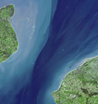
Free Picture: The Channel Tunnel
|
Description
The Channel Tunnel is a 50.5 km-long rail tunnel beneath the English Channel at the Straits of Dover. It connects Dover, Kent in England with Calais, northern France. The undersea section of the tunnel is unsurpassed in length in the world. A proposal for a Channel tunnel was first put forward by a French engineer in 1802. In 1881, a first attempt was made at boring a tunnel from the English side; the work was halted after 800 m. Again in 1922, English workers started boring a tunnel, and advanced 120 m before it too was halted for political reasons. The most recent attempt was begun in 1987, and the tunnel was officially opened in 1994. At completion it was estimated that the project cost around $18 billion. It has been operating at a significant loss since its opening, despite trips by over 7 million passengers per year on the Eurostar train, and over 3 million vehicles per year. With its 14 spectral bands from the visible to the thermal infrared wavelength region, and its high spatial resolution of 15 to 90 meters (about 50 to 300 feet), ASTER images Earth to map and monitor the changing surface of our planet. ASTER is one of five Earth-observing instruments launched December 18, 1999, on NASA's Terra satellite. The instrument was built by Japan's Ministry of Economy, Trade and Industry. A joint U.S./Japan science team is responsible for validation and calibration of the instrument and the data products. The broad spectral coverage and high spectral resolution of ASTER provides scientists in numerous disciplines with critical information for surface mapping, and monitoring of dynamic conditions and temporal change. Example applications are: monitoring glacial advances and retreats; monitoring potentially active volcanoes; identifying crop stress; determining cloud morphology and physical properties; wetlands evaluation; thermal pollution monitoring; coral reef degradation; surface temperature mapping of soils and geology; and measuring surface heat balance. The U.S. science team is located at NASA's Jet Propulsion Laboratory, Pasadena, Calif. The Terra mission is part of NASA's Science Mission Directorate.
Keywords
aster, channel, channel tunnel, dover, english channel, france, geography, jpl, nasa, rail tunnel, straits of dover, the channel tunnel, free photography, free photo, free photos, free picture, free pictures, free image, free images
|
Similar Free geography Pictures
|
|
|
|


