|
TERMS OF USE:
This free image can only be used for non-commercial, personal
website use only. THIS IMAGE CANNOT BE
used in galleries, downloaded to your computer, posted on sites for
others to use, manipulated, downsized, or upsized. If you are confused about the
terms of use or have any questions then contact us before using the image.
Free Picture: Augustine Volcano
|
Description
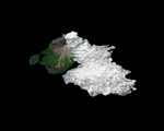
Image of Augustine Volcano, Cook Inlet, Alaska, January 12th 2006. Since last spring, the U.S. Geological Survey's Alaska Volcano Observatory (AVO) has detected increasing volcanic unrest at Augustine Volcano in Cook Inlet, Alaska near Anchorage. Based on all available monitoring data, AVO regards that an eruption similar to 1976 and 1986 is the most probable outcome. During January, activity has been episodic, and characterized by emission of steam and ash plumes, rising to altitudes in excess of 9,000 m (30,000 ft), and posing hazards to aircraft in the vicinity. An ASTER image was acquired at 12:42 AST on January 12, 2006, during an eruptive phase of Augustine. The perspective rendition shows the eruption plume derived from the ASTER image data. ASTER's stereo viewing capability was used to calculate the 3-dimensional topography of the eruption cloud as it was blown to the south by prevailing winds. From a maximum height of 3060 m (9950 ft), the plume cooled and its top descended to 1900 m (6175 ft). The perspective view shows the ASTER data draped over the plume top topography, combined with a base image acquired in 2000 by the Landsat satellite, that is itself draped over ground elevation data from the Shuttle Radar Topography Mission. The topographic relief has been increased 1.5 times for this illustration. Comparison of the ASTER plume topography data with ash dispersal models and weather radar data will allow the National Weather Service to validate and improve such models. These models are used to forecast volcanic ash plume trajectories and provide hazard alerts and warnings to aircraft in the Alaska region.
Keywords
ak, alaska, ash plume, augustine volcano, avo, cook inlet, earth science, geography, jpl, nasa, volcano, volcanoes, free photography, free photo, free photos, free picture, free pictures, free image, free images
|
Similar Free geography Pictures
|
|
|
|


