|
TERMS OF USE:
This free image can only be used for non-commercial, personal
website use only. THIS IMAGE CANNOT BE
used in galleries, downloaded to your computer, posted on sites for
others to use, manipulated, downsized, or upsized. If you are confused about the
terms of use or have any questions then contact us before using the image.
Free Picture: Alpine Fault, New Zealand
|
Description
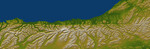
The Alpine fault runs parallel to, and just inland of, much of the west coast of New Zealand's South Island. This view was created from the near-global digital elevation model produced by the Shuttle Radar Topography Mission (SRTM) and is almost 500 kilometers (just over 300 miles) wide. Northwest is toward the top. The fault is extremely distinct in the topographic pattern, nearly slicing this scene in half lengthwise. In a regional context, the Alpine fault is part of a system of faults that connects a west dipping subduction zone to the northeast with an east dipping subduction zone to the southwest, both of which occur along the juncture of the Indo-Australian and Pacific tectonic plates. Thus, the fault itself constitutes the major surface manifestation of the plate boundary here. Offsets of streams and ridges evident in the field, and in this view of SRTM data, indicate right-lateral fault motion. But convergence also occurs across the fault, and this causes the continued uplift of the Southern Alps, New Zealand's largest mountain range, along the southeast side of the fault. Two visualization methods were combined to produce this image: shading and color coding of topographic height. The shade image was derived by computing topographic slope in the northwest-southeast (image top to bottom) direction, so that northwest slopes appear bright and southeast slopes appear dark. Color coding is directly related to topographic height, with green at the lower elevations, rising through yellow and tan, to white at the highest elevations.
Keywords
earth science, fault, faults, geography, indo australian and pacific tectonic plates, indo australian plate, jpl, nasa, new zealand, new zealands south island, nz, pacific tectonic plate, south island, southern alps, alpine fault, free photography, free photo, free photos, free picture, free pictures, free image, free images
|
Similar Free geography Pictures
|
|
|
|


