|
TERMS OF USE:
This free image can only be used for non-commercial, personal
website use only. THIS IMAGE CANNOT BE
used in galleries, downloaded to your computer, posted on sites for
others to use, manipulated, downsized, or upsized. If you are confused about the
terms of use or have any questions then contact us before using the image.
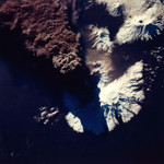
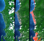
Free Picture: Tsunami Inundation, North of Phuket, Thailand
|
Description
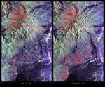
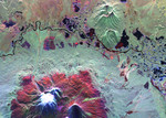
The Indian Ocean coastline north of Phuket, Thailand is a major tourist destination that was in the path of the tsunami produced by a giant offshore earthquake on December 26, 2004. This disaster resulted in a heavy loss of life. These simulated natural color ASTER (Advanced Spaceborne Thermal Emission and Reflection Radiometer) images show a 27 kilometer (17-mile) long stretch of coast 80 kilometers (50 miles) north of the Phuket airport in the Khao Lak area on December 31 (middle) and also two years earlier (left). The changes along the coast are obvious (changing from green to grey) where the vegetation was stripped away by the tsunami. The image on the right is a copy of the later ASTER scene but it includes highlighting in red for areas that have elevations within 10 meters (33 feet) of sea level. This elevation information was supplied by the Shuttle Radar Topography Mission (SRTM). The red areas appear to include most of the tsunami inundated areas. The geographic correspondence of the imaged damage and the highlighted elevation range is quite good in the middle and upper parts of the scene and is consistent with an early field report of about 10 meters of inundation. In the south, the elevation range corresponds to a much wider area than the actual damage, but this is to be expected for areas increasingly far from the coast. Offshore bathymetry (depth variations), coastal landforms, distance from the coast, and additional factors other than elevation range control the damage extent. But elevation measurements along the coast, as provided by SRTM, give a general indication of areas at risk, as now confirmed by ASTER.
Keywords
coastline, earth science, indian ocean, jpl, nasa, phuket, thailand, tsunami, tsunami inundation, free photography, free photo, free photos, free picture, free pictures, free image, free images
|
Similar Free earth science Pictures
|
|
|
|