|
TERMS OF USE:
This free image can only be used for non-commercial, personal
website use only. THIS IMAGE CANNOT BE
used in galleries, downloaded to your computer, posted on sites for
others to use, manipulated, downsized, or upsized. If you are confused about the
terms of use or have any questions then contact us before using the image.
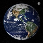
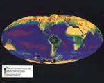
Free Picture: Global Vegetation map 6/27/1979
|
Description
This image is comprised of data from the Advanced Very High Resolution Radiometer (AVHRR) aboard the National Oceanic and Atmospheric Administration's (NOAA) Polar Orbiting Environmental Satellite (POES) series to map global vegetation cover. The vegetation covering the continents was recorded by the AVHRR aboard NOAA-7, NOAA-8, and NOAA-11. Dense vegetation is represented by shades of purple and green; sparse vegetation by shades of brown. The vegetation "index," an indicator of vegetation cover, is calculated by comparing reflected infrared light to reflected visible light for a specific area of land. NOAA's two operational polar orbiting satellites scan the entire earth once every six hours from altitudes of about 850km (529 miles). The data collected by the AVHRR sensor are held in the archives of the United States Geological Survey's EROS Data Center. The objective of the AVHRR instrument was to provide radiance data for investigation of clouds, land-water boundaries, snow and ice extent, ice or snow melt inception, day and night cloud distribution, temperatures of radiating surfaces, and sea surface temperature.
Keywords
advanced very high resolution radiometer, avhrr, earth, earth science, global vegetation, global vegetation map, nasa, national oceanic and atmospheric administration, noaa, planet earth, poes, polar orbiting environmental satellite, vegetation map, map, free photography, free photo, free photos, free picture, free pictures, free image, free images
|
Similar Free earth Pictures
|
|
|
|