
|
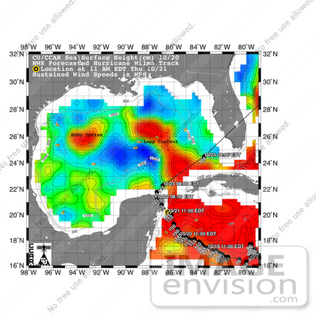
This sea surface height map of the Gulf of Mexico and the northwestern Caribbean Sea, with the Florida peninsula on the upper right, is based on altimeter data from three satellites including NASA's Jason-1. Red indicates a strong circulation of much warmer waters, which can feed energy to a hurricane. This area stands 35 to 45 centimeters (about 13 to 17 inches) higher than the surrounding waters of the Gulf. The actual track of a hurricane is primarily dependent upon steering winds, which are forecasted through the use of atmospheric models. However, the interaction of the hurricane with the upper ocean is the primary source of energy for the storm. Hurricane intensity is therefore greatly affected by the upper ocean temperature structure and can exhibit explosive growth over warm ocean currents and eddies. According to the forecasted track through the Yucatan Channel, Hurricane Wilma will cross the Yucatan Peninsula and then turn sharply to the northeast, passing over the warm waters of the Gulf of Mexico circulation feature called the Loop Current on its way towards southeast Florida. The storm may intensify as it passes over the warm water of the Loop Current. Photo Credit: NASA/JPL/University of Colorado [0003-0701-0101-4306] by 0003
|
Keywords
caribbean, earth science, florida, florida peninsula, gulf of mexico, hurricane, hurricane wilma, hurricanes, jpl, nasa, storm, storms, weather, wilma
|
|


