
|
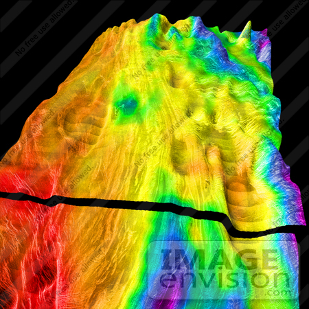
This perspective view of Venus; generated by computer from Magellan data and color-coded with emissivity; shows the boundary between the lowland plains and characteristic Venusian highland terrain in Ovda Regio; the western part of the great equatorial highland called Aphrodite Terra. For a view of the highlands just to the east; see PIA00310. The view is parallel to the northern boundary of Ovda. The black stripe in the foreground is not a data gap; the front part of the terrain has been "dropped down" to show a topographic cross-section through the region. The conical "hill" in the extreme upper right of the image is not a real feature; but an artifact resulting from a single erroneous altimeter measurement. Its size gives an idea of the horizontal resolution of the altimeter. Whereas the lowlands at left are made up of overlapping; relatively dark and unfractured lava flows; the highlands consist mainly of "tessera terrain". The tesserae in the center of the image consist mainly of ridges running nearly parallel to the highland boundary; whereas further south (to the right) the pattern is complicated by north-south trending fractures. Local depressions in the highlands; which have been partially filled in by smooth material; are visible in several places. Magellan MIDR quadrangle containing this image: C1- 00N077. Image resolution (m): 225. Size of region shown (E-W x N-S; in km): 824 x 520. Range of emissivities from violet to red: 0.67 -- 0.87. Vertical exaggeration: 40. Azimuth of viewpoint (deg clockwise from East): 165. Elevation of viewpoint (km): 520. Quadrangle name indicates approximate center latitude (N=north; S=south) and center longitude (East). Photo Credit: U.S. Geological Survey [0003-0612-3002-3835] by 0003
|
Keywords
aphrodite terra, astronomy, earth science, jpl, magellan, nasa, ovda, ovda regio, science, terrain, tessera terrain, tesserae, venus, venusian highland terrain
|
|


