|
TERMS OF USE:
This free image can only be used for non-commercial, personal
website use only. THIS IMAGE CANNOT BE
used in galleries, downloaded to your computer, posted on sites for
others to use, manipulated, downsized, or upsized. If you are confused about the
terms of use or have any questions then contact us before using the image.
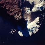
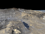
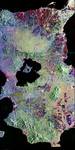
Free Picture: Amery Ice Shelf's Loose Tooth
|
Description
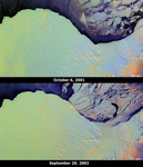
The Amery Ice Shelf is an important dynamic system responsible for draining about 16% of the grounded East Antarctic ice sheet through only 2% of its coastline. Most of the mass input to the system occurs from the Lambert and several other glaciers. Mass loss from the system occurs through basal melting and iceberg calving. These images from the Multi-angle Imaging SpectroRadiometer (MISR) portray the ice shelf front on October 6, 2001 (top) and September 29, 2002 (bottom), and illustrate changes that took place over the year elapsed between the two views. Two longitudinal rifts, oriented roughly parallel to the direction of ice flow and measuring about 25 and 15 kilometers in length, are apparent near the seaward edge of the ice shelf. Between them, a transverse fracture extends eastward from the base of the western rift. This rift system is colloquially named the Amery "loose tooth." Over the course of the one-year interval between these two MISR images, the ice front has advanced approximately 1.6 - 1.7 kilometers, and the transverse fracture and a three-way fissure at the juncture of the rifts have widened. When the transverse fracture eventually reaches the eastern rift, a large iceberg (25 kilometers x 25 kilometers) will be released. These false-color multi-angle composites combine red-band data from MISR's 60° forward, nadir, and 60° aftward viewing cameras, displayed as red, green and blue, respectively. Different colors represent angular reflectance variations. Since generally smooth surfaces predominantly forward-scatter sunlight, these appear in shades of blue. Rough surfaces tend to backward-scatter sunlight, and these appear in shades of red or orange. Low clouds appear bright purple, since they exhibit both forward and backward-scattering. Using this technique, textural variations among ice types are revealed, and clouds can be easily distinguished from ice. Illumination conditions on the two dates are nearly identical. Understanding the "normal" freq
Keywords
amery ice shelf, amery loose tooth, antarctic, earth science, east antarctic, east antarctic ice sheet, iceberg, jpl, nasa, amery ice shelfs loose tooth, free photography, free photo, free photos, free picture, free pictures, free image, free images
|
Similar Free earth science Pictures
|
|
|
|