|
TERMS OF USE:
This free image can only be used for non-commercial, personal
website use only. THIS IMAGE CANNOT BE
used in galleries, downloaded to your computer, posted on sites for
others to use, manipulated, downsized, or upsized. If you are confused about the
terms of use or have any questions then contact us before using the image.
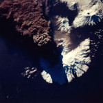
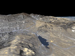
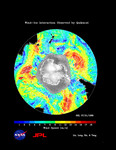
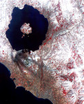
Free Picture: Clouds and Ice of the Lambert-Amery System, East Antarctica
|
Description
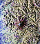
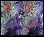
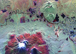
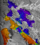
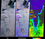
These views from the Multi-angle Imaging SpectroRadiometer (MISR) illustrate ice surface textures and cloud-top heights over the Amery Ice Shelf/Lambert Glacier system in East Antarctica on October 25, 2002. The left-hand panel is a natural-color view from MISR's downward-looking (nadir) camera. The center panel is a multi-angular composite from three MISR cameras, in which color acts as a proxy for angular reflectance variations related to texture. Here, data from the red-band of MISR's 60° forward-viewing, nadir and 60° backward-viewing cameras are displayed as red, green and blue, respectively. With this display technique, surfaces which predominantly exhibit backward-scattering (generally rough surfaces) appear red/orange, while surfaces which predominantly exhibit forward-scattering (generally smooth surfaces) appear blue. Textural variation for both the grounded and sea ice are apparent. The red/orange pixels in the lower portion of the image correspond with a rough and crevassed region near the grounding zone, that is, the area where the Lambert and four other smaller glaciers merge and the ice starts to float as it forms the Amery Ice Shelf. In the natural-color view, this rough ice is spectrally blue in color. Clouds exhibit both forward and backward-scattering properties in the middle panel and thus appear purple, in distinct contrast with the underlying ice and snow. An additional multi-angular technique for differentiating clouds from ice is shown in the right-hand panel, which is a stereoscopically derived height field retrieved using automated pattern recognition involving data from multiple MISR cameras. Areas exhibiting insufficient spatial contrast for stereoscopic retrieval are shown in dark gray. Clouds are apparent as a result of their heights above the surface terrain. Polar clouds are an important factor in weather and climate. Inadequate characterization of cloud properties is currently responsible for large uncertainties in climate prediction
Keywords
amery ice shelf, antarctica, earth science, east antarctica, geography, glacier, glaciers, ice, jpl, lambert, lambert glacier, nasa, lambert-amery system, free photography, free photo, free photos, free picture, free pictures, free image, free images
|
Similar Free earth science Pictures
|
|
|
|