|
TERMS OF USE:
This free image can only be used for non-commercial, personal
website use only. THIS IMAGE CANNOT BE
used in galleries, downloaded to your computer, posted on sites for
others to use, manipulated, downsized, or upsized. If you are confused about the
terms of use or have any questions then contact us before using the image.
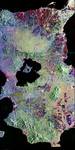
Free Picture: Great Aceh-Andaman Earthquake of 2004 Aftermath
|
Description
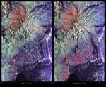
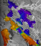
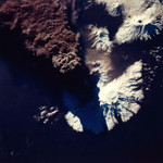
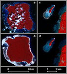
The magnitude 9.2 Indian Ocean earthquake of December 26, 2004, produced broad regions of uplift and subsidence. In order to define the lateral extent and the downdip limit of rupture, scientists from Caltech, Pasadena, Calif.; NASA's Jet Propulsion Laboratory, Pasadena, Calif.; Scripps Institution of Oceanography, La Jolla, Calif.; the U.S. Geological Survey, Pasadena, Calif.; and the Research Center for Geotechnology, Indonesian Institute of Sciences, Bandung, Indonesia; first needed to define the pivot line separating those regions. Interpretation of satellite imagery and a tidal model were one of the key tools used to do this. These pre-Sumatra earthquake (a) and post-Sumatra earthquake (b) images of North Sentinel Island in the Indian Ocean, acquired from the Advanced Spaceborne Thermal Emission and Reflection Radiometer (ASTER) instrument on NASA's Terra spacecraft, show emergence of the coral reef surrounding the island following the earthquake. The tide was 30 plus or minus 14 centimeters lower in the pre-earthquake image (acquired November 21, 2000) than in the post-earthquake image (acquired February 20, 2005), requiring a minimum of 30 centimeters of uplift at this locality. Observations from an Indian Coast Guard helicopter on the northwest coast of the island suggest that the actual uplift is on the order of 1 to 2 meters at this site. In figures (c) and (d), pre-earthquake and post-earthquake ASTER images of a small island off the northwest coast of Rutland Island, 38 kilometers east of North Sentinel Island, show submergence of the coral reef surrounding the island. The tide was higher in the pre-earthquake image (acquired January 1, 2004) than in the post-earthquake image (acquired February 4, 2005), requiring subsidence at this locality. The pivot line must run between North Sentinel and Rutland islands. Note that the scale for the North Sentinel Island images differs from that for the Rutland Island images. The tidal model used for this study was b
Keywords
aceh-andaman earthquake, earth science, earthquake, earthquakes, indian ocean, indian ocean earthquake, jpl, nasa, oceanography, science, subsidence, uplift, free photography, free photo, free photos, free picture, free pictures, free image, free images
|
Similar Free earth science Pictures
|
|
|
|