|
TERMS OF USE:
This free image can only be used for non-commercial, personal
website use only. THIS IMAGE CANNOT BE
used in galleries, downloaded to your computer, posted on sites for
others to use, manipulated, downsized, or upsized. If you are confused about the
terms of use or have any questions then contact us before using the image.
Free Picture: Drought in the Black Hills
|
Description
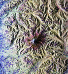
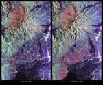
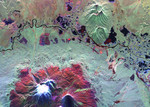
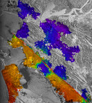
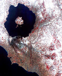
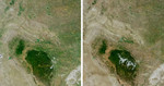
Despite good rainfall and record-setting snowstorms in the spring of 2005, most of northeastern Wyoming, the Black Hills, and western South Dakota remain in the midst of a severe drought. This set of images and maps from NASA's Multi-angle Imaging SpectroRadiometer (MISR) contrast the appearance of the Black Hills region of northwestern South Dakota on July 12, 2000 (left column), with views acquired four years later, on July 14, 2004 (right column). The natural-color images along the top are from MISR's nadir (downward-looking) camera. The browning that appears in 2004 compared with 2000 indicates that the vigor of green vegetation was significantly diminished in 2004. The color-coded maps (along the bottom) provide a quantitative measurement of the sunlight reflected from these surfaces, and the loss of sunlight-absorbing vegetation between the 2000 and 2004 dates. As the vegetation faded with the drought, the albedo at the surface increased. Albedo measures the fraction of incident sunlight that is reflected by a surface, and can vary between zero (if all the incident sunlight is absorbed and none is reflected) and one (if all sunlight is reflected and none is absorbed). Dense forest has a low albedo; bright desert, snow and clouds, have a high albedo. Here, albedo is provided for the wavelengths of sunlight that plants use for photosynthesis (400 - 700 nanometers). This measurement is known as the albedo for Photosynthetically Active Radiation (PAR). Surfaces with greater absorption of PAR appear here in blue hues, whereas surfaces with lower absorption appear as green, yellow, orange or red. Black pixels indicate areas where albedo could not be derived, usually due to the presence of clouds. In July 2004, low albedo areas (blue pixels) are notably reduced in extent, and higher albedo areas (yellow, orange and red pixels) have increased. Because incoming sunlight is scattered by tiny particles in the atmosphere, satellite measurements of albedo and other surface
Keywords
black hills, drought, droughts, earth science, jpl, nasa, south dakota, wyoming, drought in the black hills, free photography, free photo, free photos, free picture, free pictures, free image, free images
|
Similar Free earth science Pictures
|
|
|
|