
|
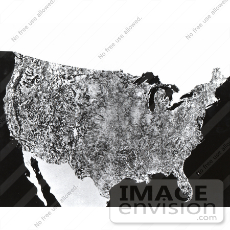
A giant photo map of the contiguous 48 states of the United States, the first ever assembled from satellite images, completed for NASA by the U.S. Department of Agriculture Soil Conservation Service Cartographic Division. The map is 10 by 16 feet, is composed of 595 cloud-free black-and-white images returned from NASA's first Earth Resources Technology Satellite (ERTS-1). The images were all taken at the same altitude (912 kilometers: 560 miles) and the same lighting angle. The images were produced by the spacecraft's Multi-spectral Scanner System (MSS) in Band 5, or the red portion of the visible spectrum, during the period July 25 to October 31, 1972. A similar mosaic has been made using Band 7, the near infrared, of the MSS. The mosaic is produced at scale of 1:1,000,000 (one inch on the mosaic equals a million inches on the ground). Enlargements of segments of the mosaic can be made up to a scale of 1:500,000. ERTS images are used for many other purposes besides cartography, including geology, hydrology, environmental and land use studies, agriculture studies, and various other areas. Photo Credit: NASA [0003-0612-0812-1557] by 0003
|
Keywords
america, black and white, continent, country, earth, earth resources technology satellite, earth science, erts, first photo of united states, first photo of us, geography, map, maps, mss, multi-spectral scanner system, nasa, north america, satellite image, satellite images, united states, usa
|
|


