
|
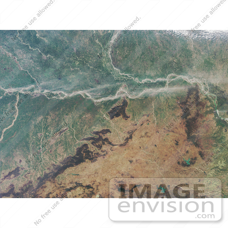
The image area encompasses the eastern Ganges plain and the States of Bihar and Jharkhand. In the top part of this image, Bihar is bisected by the Ganges River (which is also popularly known by its Hindu name, Ganga). The Son River (also spelled Sone River) joins the Ganges from the south, and the Gandak River joins from the north. A very small portion of the Gaghra River is also apparent here, as it joins with the Ganges just upstream from its confluence with the Sone. Patna, the capital city of Bihar, is located downstream from the Sone and opposite the confluence of the Ganges and the Gandak. The smaller river of Punpun only becomes navigable during the rains. Patna became a great city by about 300 BC (Patna was previously called Pataliputra). In its long history, the surrounding region has seen the rise and fall of several kingdoms and empires. There are more than twenty archaeological sites within Bihar, and there are at least three stone-age archaeological sites, including several Neolithic settlements such as the one at Chirand (which is situated about 50 kilometers from Patna). The state-owned Patna Museum boasts a large number of pre- and proto-historic objects of relevance to Indian art and history. An important painting style from Bihar is the art of the Madhubani, which is traditionally passed from mothers to their daughters. Photo Credit: NASA/GSFC/LaRC/JPL, MISR Team [0003-0612-3114-5021] by 0003
|
Keywords
bihar, earth science, gaghra river, gandak river, ganga, ganges plain, ganges river, geography, jharkhand, jpl, nasa, pataliputra, patna, punpun, punpun river, rivers, son river, sone river
|
|


