|
TERMS OF USE:
This free image can only be used for non-commercial, personal
website use only. THIS IMAGE CANNOT BE
used in galleries, downloaded to your computer, posted on sites for
others to use, manipulated, downsized, or upsized. If you are confused about the
terms of use or have any questions then contact us before using the image.
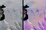
Free Picture: Arctic Sea Ice Growth
|
Description
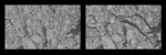
NASA image of Arctic Sea ice growth. NASA researchers have new insights into the mysteries of Arctic sea ice, thanks to the unique abilities of Canada's Radarsat satellite. The Arctic is the smallest of the world's four oceans, but it may play a large role in helping scientists monitor Earth's climate shifts. Using Radarsat's special sensors to take images at night and to peer through clouds, NASA researchers can now see the complete ice cover of the Arctic. This allows tracking of any shifts and changes, in unprecedented detail, over the course of an entire winter. The radar-generated, high-resolution images are up to 100 times better than those taken by previous satellites. The two images are separated by nine days (earlier image on the left). Both images represent an area (approximately 96 by 128 kilometers; 60 by 80 miles) located in the Baufort Sea, north of the Alaskan coast. The brighter features are older thicker ice and the darker areas show young, recently formed ice. Within the nine-day span, large and extensive cracks in the ice cover have formed due to ice movement. These cracks expose the open ocean to the cold, frigid atmosphere where sea ice grows rapidly and thickens.
Keywords
alaska, alaskan, arctic sea, arctic sea ice growth, baufort sea, earth science, ice, ice growth, jpl, nasa, free photography, free photo, free photos, free picture, free pictures, free image, free images
|
Similar Free ice Pictures
|
|
|
|