|
TERMS OF USE:
This free image can only be used for non-commercial, personal
website use only. THIS IMAGE CANNOT BE
used in galleries, downloaded to your computer, posted on sites for
others to use, manipulated, downsized, or upsized. If you are confused about the
terms of use or have any questions then contact us before using the image.
Free Picture: A Strengthening Eastern Pacific Storm
|
Description
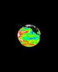
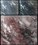
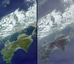
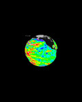
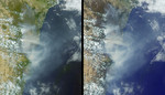
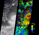
These July 11, 2006 images are from the Multi-angle Imaging SpectroRadiometer (MISR) instrument aboard NASA's Terra Satellite. They show then Tropical Storm Bud as it was intensifying into a hurricane, which it became later that day. The true-color image at left is next to an image of cloud heights on the right. Two-dimensional maps of cloud heights such as these give scientists an opportunity to compare their models against actual hurricane observations. At the time of these images, Bud was located near 14.4 degrees north latitude and 112.5 degrees west longitude, or about 620 miles (1000 kilometers) southwest of Cabo San Lucas, Baja California, Mexico. MISR was built and is managed by NASA's Jet Propulsion Laboratory, Pasadena,Calif. The Terra satellite is managed by NASA's Goddard Space Flight Center, Greenbelt, Md. JPL is a division of the California Institute of Technology.
Keywords
bud, environment, environmental, hurricane, hurricanes, jpl, misr, nasa, storm, storm bud, storms, tropical storm, tropical storm bud, tropical storms, weather, eastern pacific storm, free photography, free photo, free photos, free picture, free pictures, free image, free images
|
Similar Free environmental Pictures
|
|
|
|