|
TERMS OF USE:
This free image can only be used for non-commercial, personal
website use only. THIS IMAGE CANNOT BE
used in galleries, downloaded to your computer, posted on sites for
others to use, manipulated, downsized, or upsized. If you are confused about the
terms of use or have any questions then contact us before using the image.
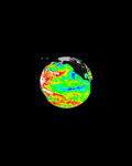
Free Picture: Dust and Sand Sweeps Over Northeast China
|
Description
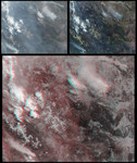
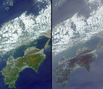
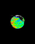
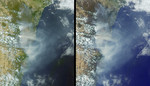
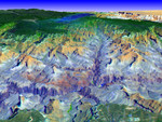
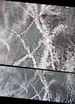
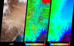
The Multi-angle Imaging SpectroRadiometer (MISR) captured these views of the dust and sand that swept over northeast China on March 10, 2004. Information on the height of the dust and an indication of the probable dust source region are provided by these images, which include a natural-color snapshot from MISR's nadir camera (left), a stereoscopically-retrieved height field (center) and a map of terrain elevation (right). The dust appears in the natural-color image as the pale brownish ripples that traverse the image from Inner Mongolia toward the southeast, over Beijing, Liaoning and Jilin Provinces. MISR's stereoscopic feature matching algorithm retrieves height above the surface where there is sufficient spatial contrast between several view angles. When the stereo matcher determines that a location is not covered by a feature above the surface, the terrain elevation data are displayed instead. The surface elevation map at right shows that the eastern portion of the image area, Liaonang and Jilin Provinces, is mostly low, flat terrain. These are the areas where the dust appears to be thickest and where the stereo height field indicates that the tops of the dust attain heights of up to about 1500 meters above the surface terrain. Clouds are situated between about 1 and 4 kilometers above the surface. The retrieved heights shown here are uncorrected for wind effects. The square-shaped area near the center of the stereo map is an artifact of the data processing. Areas where height could not be retrieved are shown in dark grey. A decrease in spring vegetation coverage in central and eastern Inner Mongolia has been suggested to be a major contributor to spring dust storms over northern China.
Keywords
dust, earth science, environment, environmental, jpl, nasa, china, free photography, free photo, free photos, free picture, free pictures, free image, free images
|
Similar Free environmental Pictures
|
|
|
|