|
TERMS OF USE:
This free image can only be used for non-commercial, personal
website use only. THIS IMAGE CANNOT BE
used in galleries, downloaded to your computer, posted on sites for
others to use, manipulated, downsized, or upsized. If you are confused about the
terms of use or have any questions then contact us before using the image.
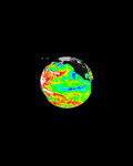
Free Picture: Aerosols over Central and Eastern Europe
|
Description
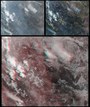
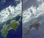
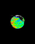
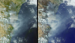
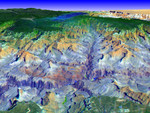
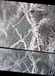
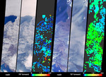
Particulate air pollution is a complex mixture of particles of varying origins and compositions. Determining the type and abundance of tiny airborne particles, known as aerosols, is needed for monitoring air quality and for understanding climate change. During the last weeks of March 2003, unusually high and widespread aerosol pollution was detected over Europe by several satellite-borne instruments. The Multi-angle Imaging SpectroRadiometer (MISR) instrument aboard NASA's Terra satellite determines aerosol amount and information about particle properties by examining the variation in scene brightness at different view angles. These images and data products illustrate the amount of aerosols on two dates over parts of Central and Eastern Europe, from the Baltic Sea in the north to the Adriatic Sea in the south. Two groups of three panels are shown. Within each group, the left and center views are natural-color images from MISR's vertical-viewing (nadir) and most obliquely forward-viewing cameras, respectively, and the right-hand panel is a map of retrieved aerosol amount, parameterized by a quantity called the optical depth. A color scale is used to represent this quantity, and high aerosol amount is indicated by yellow or green pixels, and clearer skies are indicated by blue pixels. The left-hand group of panels is comprised of data acquired on February 23, 2003, when most of the land area was still partially frozen. The right-hand group of panels portrays the same area about one month later, on March 27. The nadir camera enables surface features to stand out most clearly, whereas MISR's oblique cameras enhance sensitivity to even thin layers of aerosols. In the March image, the only strong indications of haze from the nadir view are the thin tendrils of grayish pixels over the dark waters of the Baltic Sea. Although aerosols are conventionally difficult to discern over bright surfaces, MISR is able to produce an aerosol abundance map for both the earlier snow-cover
Keywords
aerosol, aerosols, air pollution, earth science, environment, environmental, europe, jpl, nasa, pollution, aerosols over central and eastern europe, free photography, free photo, free photos, free picture, free pictures, free image, free images
|
Similar Free environment Pictures
|
|
|
|