|
TERMS OF USE:
This free image can only be used for non-commercial, personal
website use only. THIS IMAGE CANNOT BE
used in galleries, downloaded to your computer, posted on sites for
others to use, manipulated, downsized, or upsized. If you are confused about the
terms of use or have any questions then contact us before using the image.
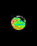
Free Picture: Aerosols over Houston and Galveston Bay
|
Description
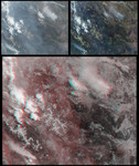
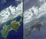
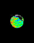
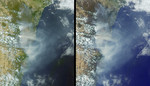
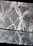
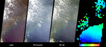
In the year 2000 Houston officially exceeded Los Angeles as the city with the worst air quality in the United States. Since then, major research has been underway to characterize the type, extent and sources of air pollutants in and around Houston. These MISR views portray Houston and Galveston Bay on September 12, 2002, and display data from three of MISR's nine cameras along with a map of retrieved aerosol optical thickness. The left-hand panel is a natural-color view from MISR's vertical-viewing(nadir) camera. The center images cover the same geographic area, from the perspectives of the 70-degree forward-viewing and 70-degree backward viewing cameras. The appearance of haze is enhanced in these oblique views, and the overall area appears significantly brighter in the oblique forward view because the atmospheric particles scatter more sunlight into the forward direction. Due to geometric parallax, clouds appear to move relative to the ground as the view angle changes. At right is a map of aerosol optical depth, a measure of the amount of aerosol present in the atmosphere and one of several key variables used to characterize their climatic and environmental influence. The extent of haze across Galveston Bay can be identified by the presence of light blue and green pixels, and places where clouds or other factors precluded a retrieval are shown in dark grey. MISR uses the changes in the atmosphere's ability to transmit light and the variation in scene brightness at different viewing angles to retrieve aerosol optical depth, and to deduce some information about particle properties, such as size, shape and composition. These data are being used as part of the Houston regional air quality study. Airborne pollution particles that contribute to the poor air quality come in part from upwind power plants and petrochemical manufacturing facilities. Over a dozen local observing stations are scattered across the area to monitor air quality. The MISR aerosol data help provide
Keywords
aerosol, earth science, environment, environmental, galveston bay, houston, jpl, nasa, pollution, aerosols over houston and galveston bay, free photography, free photo, free photos, free picture, free pictures, free image, free images
|
Similar Free environmental Pictures
|
|
|
|