|
TERMS OF USE:
This free image can only be used for non-commercial, personal
website use only. THIS IMAGE CANNOT BE
used in galleries, downloaded to your computer, posted on sites for
others to use, manipulated, downsized, or upsized. If you are confused about the
terms of use or have any questions then contact us before using the image.
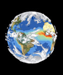
Free Picture: Satellite Image of Earth's Interrelated Systems and Climate 09/18/1997
|
Description
Satellite data and images such as those presented in this image of Earth give scientists a more comprehensive view of the Earth's interrelated systems and climate. Four different satellites contributed to the making of this image. Sea-viewing Wide Field-of-view Sensor (SeaWiFS) provided the land image layer and is a true color composite of land vegetation for cloud-free conditions from September 18 to October 3, 1997. Each red dot over South America and Africa represents a fire detected by the Advanced Very High Resolution Radiometer. The oceanic aerosol layer is based on National Oceanic and Atmospheric Administration (NOAA) data and is caused by biomass burning and windblown dust over Africa. The cloud layer is a composite of infrared images from four geostationary weather satellites NOAA's GOES 8 and 9, the European Space Agency's METEOSAT, and Japan's GMS 5.
Keywords
earth, earth science, environment, environmental, european space agency, meteosat esa, national oceanic and atmospheric administration, noaa, planet earth, radiometer, satellite data, seawifs, weather satellites, satellite, free photography, free photo, free photos, free picture, free pictures, free image, free images
|
Similar Free nasa Pictures
|
|
|
|