
|
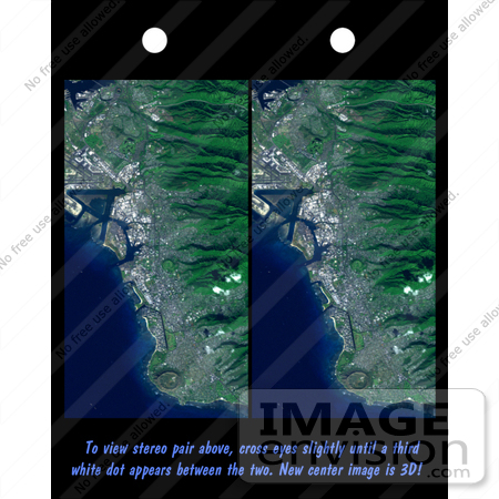
Image of Honolulu, Oahu, Hawaii. Honolulu, on the island of Oahu, is a large and growing urban area. This stereoscopic image pair, combining a Landsat image with topography measured by the Shuttle Radar Topography Mission (SRTM), shows how topography controls the urban pattern. This color image can be viewed in 3-D by viewing the left image with the right eye and the right image with the left eye (cross-eyed viewing), or by downloading and printing the image pair, and viewing them with a stereoscope. Features of interest in this scene include Diamond Head (an extinct volcano near the bottom of the image), Waikiki Beach (just above Diamond Head), the Punchbowl National Cemetary (another extinct volcano, near the image center), downtown Honolulu and Honolulu harbor (image left-center), and offshore reef patterns. The slopes of the Koolau mountain range are seen in the right half of the image. Clouds commonly hang above ridges and peaks of the Hawaiian Islands, but in this synthesized stereo rendition appear draped directly on the mountains. The clouds are actually about 1000 meters (3300 feet) above sea level. Photo Credit: NASA/JPL/NIMA [0003-0701-0820-0309] by 0003
|
Keywords
3d, diamond head, geography, hawaii, hawaiian islands, honolulu, honolulu harbor, jpl, koolau, koolau mountain range, nasa, oahu, punchbowl national cemetary, waikiki beach
|
|

