
|
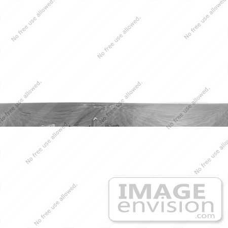
Photograph of tracks on Mars. NASA's Opportunity rover looks back at the crater where it landed and spent the first two months of its mission exploring exposed bedrock. This area may have been the shore of a shallow sea.The image is the first 360-degree view from the Mars Exploration Rover Opportunity's new position outside "Eagle Crater," the small crater where the rover landed about two months ago. Scientists are busy analyzing Opportunity's new view of the plains of Meridiani Planum. The plentiful ripples are a clear indication that wind is the primary geologic process currently in effect on the plains. The rover's tracks can be seen leading away from Eagle Crater.At the far left are two depressions - each about a meter (about 3.3 feet) across - that feature bright spots in their centers. One possibility is that the bright material is similar in composition to the rocks in Eagle Crater's outcrop and the surrounding darker material is what's referred to as "lag deposit," or erosional remnants, which are much harder and more difficult to wear away. These twin dimples might be revealing pieces of a larger outcrop that lies beneath.The depression closest to Opportunity is whimsically referred to as "Homeplate" and the one behind it as "First Base." The backshell and parachute that helped protect the rover and deliver it safely to the surface of Mars are also visible near the horizon, at the left of the image. This image was taken by the rover's navigation camera. Photo Credit: NASA/JPL-Caltech [0003-0612-0917-5735] by 0003
|
Keywords
black and white, crater, craters, eagle crater, erosional remnants, lag deposit, mars, mars exploration rover, mars landscape, meridiani planum, nasa, nasa opportunity rover, opportunity rover, pano, panorama, panoramas, panoramic, panoramics, panos, rover, rover tracks, space exploration, tracks, tracks on mars
|
|


