|
TERMS OF USE:
This free image can only be used for non-commercial, personal
website use only. THIS IMAGE CANNOT BE
used in galleries, downloaded to your computer, posted on sites for
others to use, manipulated, downsized, or upsized. If you are confused about the
terms of use or have any questions then contact us before using the image.
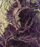
Free Picture: Wenatchee, Washington From Space
|
Description
NASA radar image of a segment of the Columbia River as it passes through the area of Wenatchee, Washington, about 220 kilometers (136 miles) east of Seattle. The Wenatchee Mountains, part of the Cascade Range, are shown in green at the lower left of the image. The Cascades create a "rain shadow" for the region, limiting rainfall east of the range to less than 26 centimeters (10 inches) per year. The radar's ability to see different types of vegetation is highlighted in the contrast between the pine forests, that appear in green and the dry valley plain that shows up as dark purple. The cities of Wenatchee and East Wenatchee are the grid-like areas straddling the Columbia River in the left center of the image. With a population of about 60,000, the region produces about half of Washington state's lucrative apple crop. Several orchard areas appear as green rectangular patches to the right of the river in the lower right center. Radar images such as these can be used to monitor land use patterns in areas such as Wenatchee, that have diverse and rapidly changing urban, agricultural and wild land pressures.
Keywords
cascade range, columbia river, from space, geography, jpl, view from space, washington, wenatchee, wenatchee from space, wenatchee mountains, wenatchee mtns, wenatchee washington, wenatchee washington from space, nasa, free photography, free photo, free photos, free picture, free pictures, free image, free images
|
Similar Free geography Pictures
|
|
|
|


