|
TERMS OF USE:
This free image can only be used for non-commercial, personal
website use only. THIS IMAGE CANNOT BE
used in galleries, downloaded to your computer, posted on sites for
others to use, manipulated, downsized, or upsized. If you are confused about the
terms of use or have any questions then contact us before using the image.
Free Picture: Rhine River From Space
|
Description
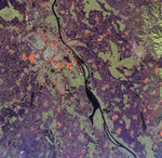
NASA radar image of the Rhine River where it forms the border between the Alsace region of northeastern France on the left and the Black Forest region of Germany on the right from space. The Rhine, one of the largest and most used waterways in central Europe, winds its way through five countries from the Swiss-Austrian Alps to the North Sea coast of the Netherlands. The river valley is densely populated, as seen in this image, which shows the French city of Strasbourg, the light blue and orange area in the upper left center; and the German cities of Kehl, across the river from Strasbourg and Offenburg, the bright area in right center. The fertile valley is famous for its wine production and most of the agricultural areas in the image, shown in purple patches, are vineyards. The light green areas are forest. Scientists can use radar images like this one to monitor the effects of urban and agricultural development on sensitive ecosystems such as the Rhine River valley.
Keywords
alsace, alsace region, black forest, black forest region, france, from space, geography, germany, jpl, kehl, netherlands, north sea, offenburg, rhine, rhine river, rhine river from space, rhine river valley, river, rivers, strasbourg, swiss-austrian alps, the rhine, view from space, nasa, free photography, free photo, free photos, free picture, free pictures, free image, free images
|
Similar Free geography Pictures
|
|
|
|


