|
TERMS OF USE:
This free image can only be used for non-commercial, personal
website use only. THIS IMAGE CANNOT BE
used in galleries, downloaded to your computer, posted on sites for
others to use, manipulated, downsized, or upsized. If you are confused about the
terms of use or have any questions then contact us before using the image.
Free Picture: Maui From Space
|
Description
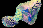
NASA radar image of the Valley Island of Maui, Hawaii. The cloud-penetrating capabilities of radar provide a rare view of many parts of the island, since the higher elevations are frequently shrouded in clouds. The light blue and yellow areas in the lowlands near the center are sugar cane fields. The three major population centers, Lahaina on the left at the western tip of island, Wailuku left of center, and Kihei in the lower center appear as small yellow, white or purple mottled areas. West Maui volcano, in the lower left, is 1800 meters high (5900 feet) and is considered extinct. The entire eastern half of the island consists of East Maui volcano, which rises to an elevation of 3200 meters (10,500 feet) and features a spectacular crater called Haleakala at its summit. Haleakala Crater was produced by erosion during previous ice ages rather than by volcanic activity, although relatively recent small eruptions have produced the numerous volcanic cones and lava flows that can be seen on the floor of the crater. The most recent eruption took place near the coast at the southwestern end of East Maui volcano in the late 1700s. Such a time frame indicates that East Maui should be considered a dormant, rather than an extinct volcano. A new eruption is therefore possible in the next few hundred years. The multi-wavelength capability of the SIR-C radar also permits differences in the vegetation cover on the middle flanks of East Maui to be identified. Rain forests appear in yellow, while grassland is shown in dark green, pink and blue. Radar images such as this one are being used by scientists to understand volcanic processes and to assess potential threats that future activity may pose to local populations.
Keywords
east maui volcano, from space, geography, haleakala, haleakala crater, hawaii, island, islands, jpl, kihei, lahaina, maui, maui from space, maui hawaii, valley island, view from space, volcano, volcanoes, wailuku, west maui volcano, nasa, free photography, free photo, free photos, free picture, free pictures, free image, free images
|
Similar Free geography Pictures
|
|
|
|


