|
TERMS OF USE:
This free image can only be used for non-commercial, personal
website use only. THIS IMAGE CANNOT BE
used in galleries, downloaded to your computer, posted on sites for
others to use, manipulated, downsized, or upsized. If you are confused about the
terms of use or have any questions then contact us before using the image.
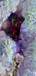
Free Picture: Death Valley
|
Description
Radar NASA image of Death Valley, California and the different surface types in the area. Radar is sensitive to surface roughness with rough areas showing up brighter than smooth areas, which appear dark. This is seen in the contrast between the bright mountains that surround the dark, smooth basins and valleys of Death Valley. The image shows Furnace Creek alluvial fan (green crescent feature) at the far right, and the sand dunes near Stove Pipe Wells at the center. Alluvial fans are gravel deposits that wash down from the mountains over time. Several other alluvial fans (semicircular features) can be seen along the mountain fronts in this image. The dark wrench-shaped feature between Furnace Creek fan and the dunes is a smooth flood-plain which encloses Cottonball Basin. Elevations in the valley range from 70 meters (230 feet) below sea level, the lowest in the United States, to more than 3,300 meters (10,800 feet) above sea level. Scientists are using these radar data to help answer a number of different questions about Earth's geology including how alluvial fans form and change through time in response to climatic changes and earthquakes. The image is centered at 36.629 degrees north latitude, 117.069 degrees west longitude. Colors in the image represent different radar channels as follows: red =L-band horizontally polarized transmitted, horizontally polarized received (LHH); green =L-band horizontally transmitted, vertically received (LHV) and blue = CHV.
Keywords
ca, calif, california, cottonball basin, death valley, death valley california, furnace creek, geography, jpl, stove pipe wells, nasa, free photography, free photo, free photos, free picture, free pictures, free image, free images
|
Similar Free california Pictures
|
|
|
|