|
TERMS OF USE:
This free image can only be used for non-commercial, personal
website use only. THIS IMAGE CANNOT BE
used in galleries, downloaded to your computer, posted on sites for
others to use, manipulated, downsized, or upsized. If you are confused about the
terms of use or have any questions then contact us before using the image.
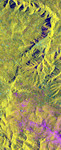
Free Picture: Lozere Department, Mende, France
|
Description
This is an X-band seasonal image of the central part of Lozere Departement situated south of the Massif Central in France. The image is 10 kilometers by 25 kilometers (6 miles by 15.5 miles) and is centered at approximately 44.3 degrees north latitude and 3 degrees east longitude. This image was acquired by the Spaceborne Imaging Radar-C/X-band Synthetic Aperture Radar aboard the space shuttle Endeavour on April 15, 1994 and on October 6, 1994. The image channels have the following color assignments: red was acquired in April; green was acquired in October; and blue is the ratio of the two data sets combined. Seasonal differences in the vegetation are visible in pink, which are heaths growing in the spring. This research area features two large limestone plateaus cut by the famous Gorges du Tarn, standing in parallel with the granite mountain range known as the Cevennes Mountains nearby. Land-use consists mainly of grasslands, heaths and forests. Forest types seen in the images are Austrian pines, Scots pines, spruce, fir and beech trees. Most forests were planted at the end of the 19th century through a national reforestation program aimed at reducing the strong erosion risks in these areas. This program was so successful that today the forests are exploited for forest pulpwood and sawlogs, but also remain protected as conservation regions. The study being performed in this area will assess the potential of spaceborne radar remote sensing for temperate forest type mapping and forest resource monitoring. The combination of X-band SAR data with lower frequency data(such as the SIR-C L-band data) allows scientists to distinguish forest tree species and biomass, or areas of ground vegetation.
Keywords
cevennes mountains, cevennes mtns, france, geography, gorges du tarn, jpl, lozere department, massif central, mende, nasa, free photography, free photo, free photos, free picture, free pictures, free image, free images
|
Similar Free geography Pictures
|
|
|
|


