|
TERMS OF USE:
This free image can only be used for non-commercial, personal
website use only. THIS IMAGE CANNOT BE
used in galleries, downloaded to your computer, posted on sites for
others to use, manipulated, downsized, or upsized. If you are confused about the
terms of use or have any questions then contact us before using the image.
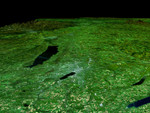
Free Picture: Syracuse, Oneida Lake
|
Description
In the lower center of this perspective view of upstate New York, the city of Syracuse hugs the southeastern banks (top right side) of Lake Onondaga, the smaller of the two dark features that dominate the scene. The view is toward the east. The urban area appears bright in stark contrast to the dark waterways and the greens, browns and yellows of the vegetated areas. Both of the two black features are lakes. Oneida Lake, the larger of the two is to the left of the scene center. About 1/3 of the way between Lakes Onondaga and Oneida are the triangular shaped runways of the Syracuse Hancock International Airport. The Adirondack Mountains are to the upper left while the less rugged Catskills can be seen in the upper right. A faint outline of the Mohawk River can be seen as threads its way down from the Adirondacks toward the city of Rome, the bright area in the valley between the lake and the Adirondacks. The Erie Canal and the Oswego River are part of the network of waterways seen in the left image foreground. Fall foliage in a variety of colors can be seen in the Landsat data used here. Redder vegetation generally occurs at higher elevations and toward the north (left), especially in the Adirondack Mountains. The back edge of the data set forms a false skyline. The image was generated using topographic data from SRTM and enhanced true-color Landsat 5 satellite images. Topographic shading in the image was enhanced with false shading derived from the elevation model. Topographic expression is exaggerated 6X. Syracuse lies at the geographic center of the state of New York and has been the site of its state fair for most of that event's 154 years. It is located in an agricultural and resort area. The yellowish rectangular features in the foreground of the image are farmlands. Parts of Skaneateles and Otisco Lakes, some of central New York's Finger Lakes, can be seen in the bottom right corner of the image.
Keywords
adirondack mountains, adirondacks, catskill mountains, catskills, erie canal, finger lakes, geography, jpl, lake onondaga, lakes, mohawk river, new york, ny, oneida lake, oswego river, otisco lake, rome new york, rome ny, skaneateles lake, syracuse, syracuse hancock international airport, nasa, free photography, free photo, free photos, free picture, free pictures, free image, free images
|
Similar Free Pictures of lakes
|
|
|
|