|
TERMS OF USE:
This free image can only be used for non-commercial, personal
website use only. THIS IMAGE CANNOT BE
used in galleries, downloaded to your computer, posted on sites for
others to use, manipulated, downsized, or upsized. If you are confused about the
terms of use or have any questions then contact us before using the image.
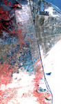
Free Picture: Suez Canal
|
Description
One of the most important waterways in the world, the Suez Canal runs north to south across the Isthmus of Suez in northeastern Egypt. This image of the canal covers an area 36 kilometers (22 miles) wide and 60 kilometers (47 miles) long in three bands of the reflected visible and infrared wavelength region. It shows the northern part of the canal, with the Mediterranean Sea just visible in the upper right corner. The Suez Canal connects the Mediterranean Sea with the Gulf of Suez, an arm of the Red Sea. The artificial canal provides an important shortcut for ships operating between both European and American ports and ports located in southern Asia, eastern Africa, and Oceania. With a length of about 195 kilometers (121 miles) and a minimum channel width of 60 meters (197 feet), the Suez Canal is able to accommodate ships as large as 150,000 tons fully loaded. Because no locks interrupt traffic on this sea level waterway, the transit time only averages about 15 hours. ASTER acquired this scene on May 19, 2000.
Keywords
canal, canals, egypt, geography, gulf of suez, isthmus of suez, jpl, mediterranean sea, red sea, suez, suez canal, waterway, waterways, nasa, free photography, free photo, free photos, free picture, free pictures, free image, free images
|
Similar Free geography Pictures
|
|
|
|


