|
TERMS OF USE:
This free image can only be used for non-commercial, personal
website use only. THIS IMAGE CANNOT BE
used in galleries, downloaded to your computer, posted on sites for
others to use, manipulated, downsized, or upsized. If you are confused about the
terms of use or have any questions then contact us before using the image.
Free Picture: Zapala, Argentina
|
Description
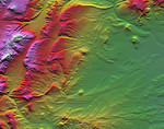
Topographic data provided by the Shuttle Radar Topography Mission can provide many clues to geologic history and processes. This view of an area southwest of Zapala, Argentina, shows a wide diversity of geologic features. The highest peaks (left) appear to be massive (un-layered) crystalline rocks, perhaps granites. To their right (eastward) are tilted and eroded layered rocks, perhaps old lava flows, forming prominent ridges. Farther east and south, more subtle and curvilinear ridges show that the rock layers have not only been tilted but also folded. At the upper right, plateaus that cap the underlying geologic complexities are more recent lava flows - younger than the folding, but older than the current erosional pattern. Landforms in the southeast (lower right) and south-central areas appear partially wind sculpted. Two visualization methods were combined to produce this image: shading and color coding of topographic height. The shade image was derived by computing topographic slope in the north-south direction. Northern slopes appear bright and southern slopes appear dark, as would be the case at noon at this latitude in the southern hemisphere. Color-coding is directly related to topographic height, with green at the lower elevations, rising through yellow, red, and magenta, to white at the highest elevations.
Keywords
argentina, geography, jpl, zapala, zapala argentina, nasa, free photography, free photo, free photos, free picture, free pictures, free image, free images
|
Similar Free geography Pictures
|
|
|
|


