|
TERMS OF USE:
This free image can only be used for non-commercial, personal
website use only. THIS IMAGE CANNOT BE
used in galleries, downloaded to your computer, posted on sites for
others to use, manipulated, downsized, or upsized. If you are confused about the
terms of use or have any questions then contact us before using the image.
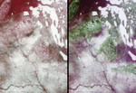
Free Picture: Saskatchewan and Manitoba
|
Description
Surface brightness contrasts accentuated by a thin layer of snow enable a network of rivers, roads, and farmland boundaries to stand out clearly in these MISR images of southeastern Saskatchewan and southwestern Manitoba. The lefthand image is a multi-spectral false-color view made from the near-infrared, red, and green bands of MISR's vertical-viewing (nadir) camera. The righthand image is a multi-angle false-color view made from the red band data of the 60-degree aftward camera, the nadir camera, and the 60-degree forward camera. In each image, the selected channels are displayed as red, green, and blue, respectively. The data were acquired April 17, 2001 during Terra orbit 7083, and cover an area measuring about 285 kilometers x 400 kilometers. North is at the top. The junction of the Assiniboine and Qu'Apelle Rivers in the bottom part of the images is just east of the Saskatchewan-Manitoba border. During the growing season, the rich, fertile soils in this area support numerous fields of wheat, canola, barley, flaxseed, and rye. Beef cattle are raised in fenced pastures. To the north, the terrain becomes more rocky and forested. Many frozen lakes are visible as white patches in the top right. The narrow linear, north-south trending patterns about a third of the way down from the upper right corner are snow-filled depressions alternating with vegetated ridges, most probably carved by glacial flow. In the lefthand image, vegetation appears in shades of red, owing to its high near-infrared reflectivity. In the righthand image, several forested regions are clearly visible in green hues. Since this is a multi-angle composite, the green arises not from the color of the leaves but from the architecture of the surface cover. Progressing southeastward along the Manitoba Escarpment, the forested areas include the Pasquia Hills, the Porcupine Hills, Duck Mountain Provincial Park, and Riding Mountain National Park. The forests are brighter in the nadir than at the oblique an
Keywords
assiniboine river, duck mountain provincial park, geography, jpl, lake manitoba, manitoba, manitoba escarpment, pasquia hills, porcupine hills, qu apelle river, quapelle river, riding mountain national park, saskatchewan, saskatchewan and manitoba, saskatchewan river, nasa, free photography, free photo, free photos, free picture, free pictures, free image, free images
|
Similar Free geography Pictures
|
|
|
|


