|
TERMS OF USE:
This free image can only be used for non-commercial, personal
website use only. THIS IMAGE CANNOT BE
used in galleries, downloaded to your computer, posted on sites for
others to use, manipulated, downsized, or upsized. If you are confused about the
terms of use or have any questions then contact us before using the image.
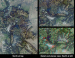
Free Picture: Smoke over Jackson Hole
|
Description
These Multi-angle Imaging SpectroRadiometer (MISR) images acquired on July 27, 2001 (Terra orbit 8554) show the area around Jackson Hole, Wyoming, where the Green Knoll forest fire has raged for many days. Due to this year's low humidity, officials from the Grand Teton National Park and Bridger-Teton National Forest Interagency Fire Management Office announced a high risk for the area. The Green Knoll blaze is suspected to have been sparked by a campfire, and is located a few kilometers southwest of the town of Jackson. About 4600 acres have been scorched by the fire. Mandatory evacuations of some of the subdivisions near the town of Wilson were ordered, and on July 27 the fire had crept to within 300 meters of buildings. By July 29, the fire was reported to be 60-70% contained, thanks to the valiant efforts of over 1000 firefighters and the assistance of about one-fourth of the nation's air tankers. Improved weather conditions, including lighter winds, cooler temperatures and higher humidity, also helped matters. At the left of this image set is a true-color view from MISR's 70-degree forward-viewing camera, covering an area of about 240 kilometers x 340 kilometers. The oblique angle of view accentuates the visibility of smoke, which can be seen as a thin bluish-white haze over the Jackson Hole valley. At top right is a cropped version of this picture, rotated counterclockwise to facilitate comparison with the stereo anaglyph beneath it. The anaglyph was created from MISR's 70-degree and 60-degree forward views, and requires a rotated orientation in order to produce a 3-D effect. Viewing the anaglyph in stereo helps to visualize the local topography and to differentiate the Green Knoll smoke plume from the higher nearby clouds. Stereoscopic viewing requires red/blue glasses with the red filter placed over your left eye. Information on ordering 3-D glasses is availablehere. Yellowstone Lake is visible at the center of the left-hand image, and is surrounded by Yellow
Keywords
continental divide, fire, fires, forest fire, forest fires, gannett peak, geography, green knoll blaze, green knoll forest fire, jackson hole, jackson hole wyoming, jpl, national park, national parks, smoke, smoke over jackson hole, smoke plumes, teton range, wind river range, wyoming, yellowstone, yellowstone lake, yellowstone national park, yellowstone np, nasa, free photography, free photo, free photos, free picture, free pictures, free image, free images
|
Similar Free geography Pictures
|
|
|
|


