|
TERMS OF USE:
This free image can only be used for non-commercial, personal
website use only. THIS IMAGE CANNOT BE
used in galleries, downloaded to your computer, posted on sites for
others to use, manipulated, downsized, or upsized. If you are confused about the
terms of use or have any questions then contact us before using the image.
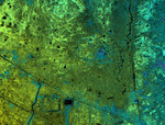
Free Picture: Lovea, Cambodia
|
Description
This image of Lovea, Cambodia, was acquired by NASA's Airborne Synthetic Aperture Radar (AIRSAR). Lovea, the roughly circular feature in the middle-right of the image, rises some 5 meters (16.4 feet) above the surrounding terrain. Lovea is larger than many of the other mound sites with a diameter of greater than 300 meters (984.3 feet). However, it is one of a number highlighted by the radar imagery. The present-day village of Lovea does not occupy all of the elevated area. However, at the center of the mound is an ancient spirit post honoring the legendary founder of the village. The mound is surrounded by earthworks and has vestiges of additional curvilinear features. Today, as in the past, these harnessed water during the rainy season, and conserved it during the long dry months of the year. The village of Lovea located on the mound was established in pre-Khmer times, probably before 500 A.D. In the lower left portion of the image is a large trapeng and square moat. These are good examples of construction during the historical 9th to 14th Century A.D. Khmer period; construction that honored and protected earlier circular villages. This suggests a cultural and technical continuity between prehistoric circular villages and the immense urban site of Angkor. This connection is one of the significant finds generated by NASA's radar imaging of Angkor. It shows that the city of Angkor was a particularly Khmer construction. The temple forms and water management structures of Angkor were the result of pre-existing Khmer beliefs and methods of water management.
Keywords
cambodia, circular village, circular villages, geography, jpl, lovea cambodia, nasa, radar image, radar images, village of lovea, lovea, free photography, free photo, free photos, free picture, free pictures, free image, free images
|
Similar Free geography Pictures
|
|
|
|


